Non-governmental organisation (NGO) Planact has partnered with Google Earth to put South Africa’s informal settlements on the map.
According to the NGO, access to informal settlements has always been a challenge when it comes to emergency services and transport route mapping.
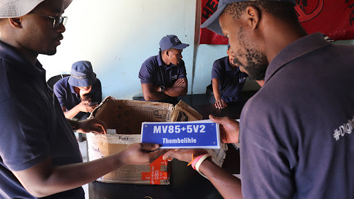
The partnership between Planact and Google Earth has introduced “Plus Codes”, which are digital addresses that offer a near-instant solution for households in informal settlements.
Plus Codes are street addresses for people or places that don’t have one, says Google. Instead of addresses with street names and numbers, Plus Codes are based on latitude and longitude, and displayed as numbers and letters.
With a Plus Code, people can receive deliveries, access emergency and social services, or help other people find them.
Rapid urbanisation challenges
Mike Makwela, senior programme coordinator at Planact, says: “The organisation was founded in 1985 to assist communities in advocating for alternative development plans during the apartheid era.
“Over the years, Planact expanded its mission to support and mobilise community processes that enhance good governance at a local level, ultimately improving living conditions and reducing poverty in communities.”
Planact notes it chose to initiate this project because of the challenges that rapid urbanisation in South Africa present.
It explains that this influx of people – often youth – seeking economic opportunities in cities, has resulted in growing informal settlements.
“Because they grow organically, there is a disconnect between demand and supply for essential services. In some cases, land earmarked for other developments is occupied, further complicating the challenge,” the NGO says.
It points out that the problem lies in the fact that informal settlements are often excluded from city-wide planning, which means no physical addresses and little or no access to vital city services, among other things.
Emergency services, including police, fire brigades and ambulances, rely on GPS. The lack of a physical address can lead to critical delays in reaching emergency scenes, it says, adding this in turn poses a serious risk to community members’ safety.
“Planact recognised the need for a comprehensive addressing system in well-established informal settlements. We partnered with Google Earth, to harness the power of technology to integrate these communities and introduced what we call Plus Codes–digital addresses,” Makwela says.
The NGO notes the initiative starts with inclusive mapping. Community members – who know the locations intimately – participate by mapping their settlements, marking landmarks and communal spaces.
Community volunteers are then trained to use the Address Maker application, addressing different types of structures within the settlements, it adds.
“It’s important to remember that Planact and its partners provide much-needed work opportunities for community members,” says Makwela.
“Now, as one of the Social Employment Fund’s strategic implementation partners, we are training 24 participants from the Tjovitjo informal settlement in Ennerdale South, Johannesburg, in Geographic Information System – or GIS skills. This to generate Plus Codes for their residential areas.”
Promoting safety
The participants – who earn a stipend – will learn to develop a settlement layout map of their community.
They will then be taught how to use Google’s open source mapping software to generate Plus Codes and install one in each yard of the settlement.
“The outcome of this project is nothing short of transformative. Informal settlements are being digitally integrated into the larger urban landscape, enabling residents to access goods and services online, which can be delivered to their Plus Codes,” says Makwela.
“In addition to emergency services, e-hailing and online deliveries can now take place, which includes the delivery of textbooks and academic material for students studying remotely.”
According to the organisation, digital addresses also help promote safety.“Children and other vulnerable residents can be dropped off at the entrance to their homes and, in the case of domestic and gender-based violence, police can process more cases by having accurate residential addresses,” it says.
“This newfound access eliminates various challenges, from transportation issues to improved safety. Things many of us take for granted.”
“The technology already exists, as does the labour force, so the same approach can be taken in any geographical location. The community mapping and application of the address boards are easily replicable and the concept is relatively cheap to scale,” Makwela concludes.
Share